On 17th July hubby and I visited Zao Quasi National Park. The mountain park extends over both Miyagi and Yamagata prefectures in north-eastern Japan. The park consists of Mount Omoshiroyama of Ou Mountains, and continues south and includes Zao Mountain Range Park. Zao Mountain Range is in fact a part of Ou Mountains. Zao Mountain Range has various active volcanic terrains and the central area of the range has three dominant mountains, namely Mount Kumanodake (1841 meters), Mount Goshikidake (1674 meters), and Mount Kattadake (1759 meters). Zao Quasi National Park was established in 1963 and covers an area of 400 square kilometers. The area from around a crater lake named Okama to Mount Fubosan of Zao Mountain Range has been designated as specially protected region of this park. The park is well known for its unparallel splendor and scenic views. The park contains many unique geological features such as gorges, rocks, marshlands, and Okama Crater Lake which is the scenic symbol of the park. The park is also known for the existence of lush and diverse vegetation such as Beech forests and alpine vegetation. The park is very popular for various resort facilities such as skiing areas and hot springs. The skiing resorts are also well known for heavily snowed-in frozen trees called Juhyo snow monsters that are formed during mid-winter by strong winds from Siberia. The park is also a popular spot for trekking and hiking during summer and autumn.
Zao Quasi National Park is located about 220 kilometers southeast of our home and it took us almost 5 hours to reach the destination by car. When we were about 27 kilometers away from our destination, we left the expressway and drove along a road named Zao Echo Line. It is a tolled road that winds across Zao Mountain Range and connects Yamagata prefecture and Miyagi prefecture. The road is closed during winter season. The road is surrounded by pleasant breathtaking scenic views. On our way up the mountains along this road, we stopped at a sightseeing spot to see two waterfalls. This spot has a lookout stand, and we enjoyed seeing many mountains covered with lush green vegetation. To our left we saw a waterfall named Kaerazu-no-taki which is located in the eastern part of Mount Goshikidake. The source of water of this waterfall is Okama Crater Lake. The waterfall is 97.5 meters high and has a width of 14 meters. We loved the sound of the waterfall and it was so relaxing. From the lookout stand, to our right we saw another cascading waterfall named Furikotaki which flows in the northeast of Mount Goshikidake. The source of water of this waterfall is Furiko marsh. When a strong wind blows, this fall swings like a pendulum. The scenery around us was so beautiful and peaceful. In striking contrast to the mountain greenery, there are huge areas on the mountain covered with volcanic ejects which are brown to brownish rocks and pebbles. We took several photos and also compiled a video of this wonderful spot.

Hubby standing next to an information board at the sightseeing spot
Zao Quasi National Park is located about 220 kilometers southeast of our home and it took us almost 5 hours to reach the destination by car. When we were about 27 kilometers away from our destination, we left the expressway and drove along a road named Zao Echo Line. It is a tolled road that winds across Zao Mountain Range and connects Yamagata prefecture and Miyagi prefecture. The road is closed during winter season. The road is surrounded by pleasant breathtaking scenic views. On our way up the mountains along this road, we stopped at a sightseeing spot to see two waterfalls. This spot has a lookout stand, and we enjoyed seeing many mountains covered with lush green vegetation. To our left we saw a waterfall named Kaerazu-no-taki which is located in the eastern part of Mount Goshikidake. The source of water of this waterfall is Okama Crater Lake. The waterfall is 97.5 meters high and has a width of 14 meters. We loved the sound of the waterfall and it was so relaxing. From the lookout stand, to our right we saw another cascading waterfall named Furikotaki which flows in the northeast of Mount Goshikidake. The source of water of this waterfall is Furiko marsh. When a strong wind blows, this fall swings like a pendulum. The scenery around us was so beautiful and peaceful. In striking contrast to the mountain greenery, there are huge areas on the mountain covered with volcanic ejects which are brown to brownish rocks and pebbles. We took several photos and also compiled a video of this wonderful spot.


A compiled video of the mountain range and the waterfalls as viewed from the lookout stand
After driving for a few more kilometers up the mountains on Zao Echo Line, we stopped at a second sightseeing spot overlooking a rugged mountain named Daikokuten. This spot is located at an altitude of 1432 meters and a volcanic eruption caused the formation of almost barren slopes of this mountain. The contrast between the whitish brown slopes of this mountain and the greenery of other mountains in the background is so striking and remarkable. From this spot, there is a walking trail that takes visitors to the top of Mount Kattadake in an hour. On this trail a stone statue of Daikoku deity is enshrined. But we did not see the deity as we opted to go to Kattadake mountaintop by our car.

Hubby standing next to an information board located near the walking trail on Mount Daikokuten


During the car drive, when we were about 1.5 kilometers away from the top of Mount Kattadake, we left Zao Echo Line Road and drove along another road named Zao High Line. It is a tolled road and ends at a car parking area near Zao Rest House located on the top of Mount Kattadake.
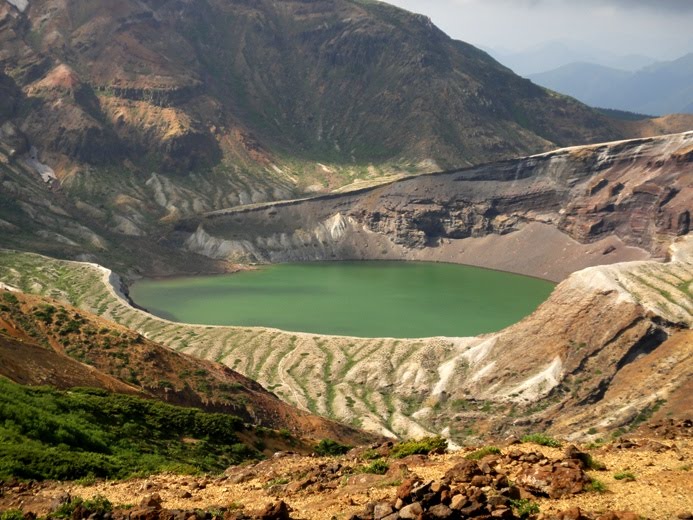
Since we could go up to the top of Mount Kattadake (1759 meters) by our car, we were able to walk up to Okama Lake within just ten minutes. The lake is located in the central part of Zao Mountain Range, and is surrounded by three mountains namely, Mount Kumanodake, Mount Goshikidake (1674 meters), and Mount Kattadake. In fact Okama Lake is a crater lake located at the center of Goshikidake tuff cone. The lake is called Okama because its round shape resembles an iron kettle pot (okama in Japanese). The lake is about 1080 meters in circumference, 27 meters in depth, and is nearly circular with the east-west diameter of 325 meters and the north-south diameter of 335 meters. The water of the lake is acidic and is uninhabitable for all kinds of organisms. The lake is also known as Goshikinuma (lake of five colors) because the color of the lake changes according to the weather and the angle of the sunlight. The lake is very rare in the world because the temperature of the water falls to 2 degrees Celsius from the surface of the lake to the halfway point and rises from there to the bottom.The lake is considered to be the symbol of Zao Quasi National Park and is a major sightseeing attraction of the area.
From the top of Mount Kattadake, we walked along a walking trail set around Okama Crater Lake and reached a spot located southwest of the lake. From this spot, we got a stunning and fascinating view of the emerald green colored lake with a mystic atmosphere. The color of the lake is in striking contrast to the dull colored crater walls. We took several photos of the lake and its surroundings from this spot.


Next, we walked along the trail towards the north and reached another spot located west-southwest of Okama Lake. This spot was the nearest we could get to the lake. From this spot we got yet another amazing view of the lake. Again we took several photos of the lake and its surroundings from this spot.


Afterwards, we turned around and started walking back towards the south on the walking trail. We walked for about 15 minutes along the trail and then climbed many paved stone steps that led to the top of Mount Kattadake. While climbing up the steps, we could see Okama Lake from yet another angle, and it was wonderful to see how the lake and its surrounding looked different and mysterious from different spots and positions.


After climbing the stone steps for about 10 minutes, we reached the highest point at the top of Mount Kattadake. This mountain is located to the south of Okama Lake, and we got a wonderful view of the lake from this spot at the top of the mountain. We took several photos of the lake and its surroundings from this spot also.


Afterwards, we visited a shrine named Kattamine Jinja located at the top of Mount Kattadake. A shrine of the same name is located near the foot of the mountain at Togatta hot spring. The shrine at the mountaintop is known as Okumiya and the one at the base is known as Satomiya. Deities named Amenomikumari-no-kami and Kuninomikumari-no-kami are enshrined at this shrine.


Adjacent to the rest house at the top of Mount Kattadake, we saw people using chairlift facility to go to the base of the mountain. Zao-Katta Chairlift operates between the mountaintop and the base of Mount Kattadake. We paid 700 Yen per person for the round-trip ticket to ride on the chairlift. The ride from the mountaintop station to the base station was wonderful, and hubby compiled a video of this ride. We enjoyed viewing the vegetation on the slopes of the mountain. It was really fun. Since our car was parked at the top of the mountain, we again returned back to the mountaintop station by the chairlift.


A compiled video of the chairlift ride from the mountaintop station to the base station

We really enjoyed our visit to Zao Quasi National Park. We loved the spectacular and mysterious Okama Crater Lake.


